Pilots make fewer errors when they know what to expect. For this reason, the FAA recommends airports mitigate the risk of such uncertainty by implementing standard taxiway widths, turn angles, and other geometric factors. Still, cases of non-standard airport geometry exist, and through ATR research, they’ve been identified as a contributing factor to runway incursions.
A runway incursion is characterized by the incorrect presence of a person, vehicle, or aircraft on the protected area of an airport’s takeoff or landing surface. In order to reduce these occurrences,the FAA’s Runway Incursion Mitigation (RIM) Program identifies and mitigates nonstandard geometry factors at airport locations experiencing a high number of runway incursions.
The RIM Program has made significant progress since taking off in 2015. As of June 2019, 39 RIM locations have undergone site-specific enhancements including taxiway reconfigurations and changes to lighting, markings, and aircraft operations. Airport planners and designers rely on FAA’s RIM mitigation guidance materials and support from FAA Regional program contacts.
The RIM program is built on more than ten years’ worth of runway incursion data. Over 10,000 runway incursions, and 6,000 non-standard runway/ taxiway intersections at more than 500 airports have been georeferenced and assessed by the FAA and incorporated into a Geographic Information System Database that, when applicable, associates incursions with non-standard geometry sites and known hot spots.
While unique conditions and considerations distinguish individual RIM locations across the nation, there are commonalities in the types of taxiway geometry issues encountered at all of these sites.
In order to categorize the challenges and applicable solutions, FAA has defined 19 common geometry elements, or geocodes, that may be present at RIM locations. The agency provides geometry-based approaches through its “RIM Toolbox” guide to help airports tackle issues like Geocode #3: Wide expanses of taxiway pavement along a runway and #8: Direct taxiing access to runways from ramp areas.
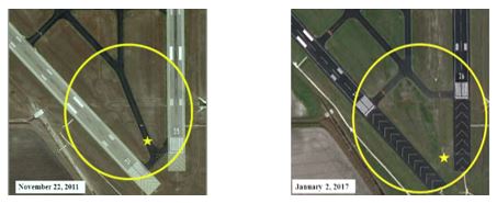
The array of completed mitigation projects at U.S. airports illustrate the success of geocode guidance paired with expertise and support from stakeholders. One general aviation airport, for instance, had experienced 15 runway incursions between 2008 and 2014 at a RIM location that was also a designated hot spot. With FAA support, that airport addressed geocodes including #6: Two runway thresholds in close proximity and #18: Unexpected holding position marking along a taxiway. After completing the projects necessary to meet current standards, the area’s hot spot was removed, and no runway incursions have occurred there since its mitigation. Its configuration before and after are pictured below:

All towered airports are evaluated each year to monitor changes or mitigations at known non-standard geometry locations and to identify new areas in need of mitigation.
This program’s management of high-risk areas underscores the FAA’s continuing mission to provide the safest, most efficient aerospace system in the world. Its sustained progress is only possible thanks to continued support from airports and industry.
Learn more at the RIM Website.